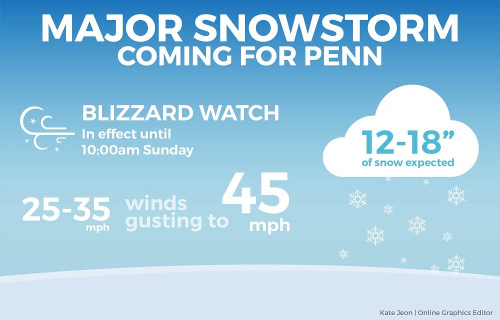
If you want to go to a BYO downtown this weekend, you might want to consider staying closer to campus. Philadelphia is expected to receive 12 to 18 inches of snow starting late Friday night.
The National Weather Service has put the city on Blizzard Warning until 10 a.m. on Sunday. I predict the snow will begin to fall between 9 p.m. and 12 a.m. Friday night. If you’re planning on doing a lot of activities on Saturday and Sunday, I’d rethink that very soon unless they involve throwing snowballs, skiing down Locust or snow angel making.
Whenever I prepare a forecast for a storm, I try to do three things: 1) look at the best case or least impactful scenario, 2) look at the worst case or most impactful scenario and 3) look for a middle ground. From there, I try to hone in on what the middle ground might be and tend to lean towards that particular solution for my forecast.
With this particular snowstorm, the middle ground for me is more towards the worst-case scenario versus the best-case. That isn’t based on what some “computer model” says or what I want to happen because models are simply used for guidance and don't make up an actual forecast. This forecast is based on observations and what the atmosphere looks like.

Philadelphia has not seen over a foot of snow in quite a while and I expect significant impacts as a result of the snow. Road, train, and air travel will be stalled and virtually nonexistent for a better part of the weekend, and the intensity of the snowfall will create blinding conditions. On Thursday, American Airlines announced cancellation of all of its flights going out of Philadelphia and other airports in the Mid-Atlantic on Saturday. Imagine not being able to see the high rises from the 38th Street bridge.
The definition of a blizzard actually has very little to do with the snow and more to do with the wind. The National Weather Service defines a blizzard as a storm that contains large amounts of snow or blowing snow, with winds in excess of 35 mph and visibilities of less than 1/4 mile for at least 3 hours. Add winds expected to be upwards of 25-35 mph, and you have the formula for a blizzard. With that comes the potential for fallen trees and power lines, which could lead to some power outages.
Outside of Penn, coastal flooding and beach erosion at the Jersey Shore will be extremely dangerous, with waves cresting at major levels. Combine that with 60 mph winds and a full moon, and that only spells incredible damage for those areas.
RELATED:
Expect two snow days this winter
As Philadelphia readies for snow, Penn Wrestling readies for Binghamton
This isn’t a storm that should be taken lightly.