Mitch Yanak isn’t your typical Division of Public Safety officer. His job isn’t about arresting criminals or patrolling Locust Walk.
Yet he and his team are at the forefront of fighting crime by staring at computer screens, analyzing data sheets and literally keeping track of crimes on Penn’s campus through a state-of-the-art mapping system.
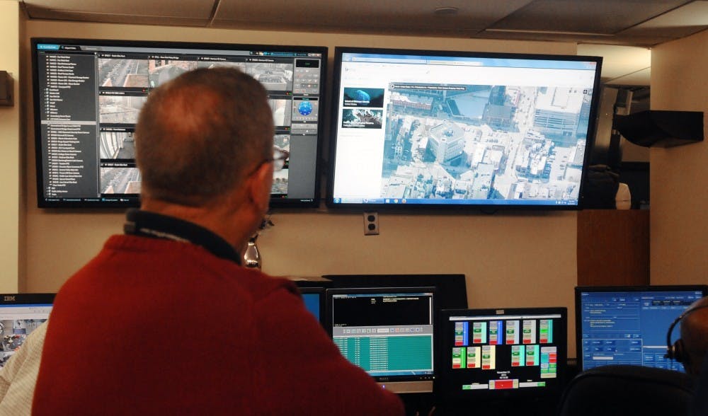
Yanak is the director of Communications for the Division of Public Safety, commonly known as PennComm. Described internally as the “eyes and ears” of Penn Police, PennComm serves as the center for processing emergency calls and dispatching police officers. Deep inside the PennComm office at 4040 Chestnut St., there is a desk armed with almost 10 computer screens of different sizes — the crime map desk.
DPS’s crime mapping system is consistently being updated with new technology. The most recent addition to the map allows Yanak and his team to mark locations of interest for recently released criminals, thanks to a database shared by the Philadelphia Police Department.
“Not every university is able to get crime data from the police department in its city,” Vice President for Public Safety Maureen Rush said. “We benefit from our great relationship with the Philadelphia Police.” Both Rush and Yanak, like numerous DPS officers, had worked for the Philadelphia Police before coming to Penn.
The daily-updated crime map keeps track of reported incidents either shared by the Philadelphia Police Department or gathered by Penn Police. But the system does much more than just mark circles on a map. It can analyze aggregated crime data and transform it into useful information for making predictions. By counting the occurrence and frequency of crimes categorized by location and time — on the month, week, day and hour level — the system can identify crime patterns and point officers in the right direction for solving or preventing crimes.
PennComm operators usually set a threshold for each type of crime, and when the system detects that the actual occurrence of that crime reached the threshold, it will automatically send a notification to all relevant DPS officers.
The area monitored by the crime map system spans from 20th Street on the east to 60th Street on the west, and from Girard Avenue in the north to Passyunk Avenue in the south. It is a significantly larger area than the Penn Patrol Zone, but Yanak said this is necessary for tracking crime and taking preemptive measures. “It’s important not only to know what happens in your area, but what happens around you,” he said.
Dispatchers also have access to the crime map system, which helps them guide officers to crime locations and familiarize them with the surrounding environment, such as roads and buildings. Even a new officer on his first day will know how to get to Huntsman Hall or the Quadrangle from any location on campus, Yanak said.
Rush said the success of this summer’s retail-theft task force — which reduced retail thefts by 75 percent at top theft locations — can be largely attributed to the crime map system. Yanak and his crew used the crime map system to go over data of retail theft over the past few years to pick the locations that retail thefts happened most frequently. DPS then dispatched Penn Police officers and AlliedBarton guards to stand in front of the stores in order to deter crime.
PennComm has been using its crime map system for nine years — a significant upgrade to pre-modern technology. “In the old days, you would have a map on the wall and put pins of different colors on it [to mark crime],” Yanak said. There were dangers doing this, Yanak said, because pins can be easily moved around and they may fall off from the map, which could damage the accuracy of crime tracking. Over the past nine years, the system has been upgraded with new features whenever there was a chance.
Police officers started using digital crime maps about 20 years ago, said Penn Law professor of law and criminology Stephanos Bibas. One of the first police departments to start using these crime maps was the New York City Police Department, which used a system called CompStat to track all types of crime, the locations and the time periods.
“Having the information was extremely valuable,” Bibas said. “By having this information, they could make better and more effective use of police force and resources.
“You are able to see the pattern you can’t figure out until you look at the map. Modern technology has made pattern recognition a lot easier,” Bibas said.